[china] the scope of the threat [part 4]
 Hill of Megiddo underlined
China and the Silk Road
Basically, the Silk Road splits three ways, through Langzhou, Chengdu and Kunming. The latter takes you south and the former two the way to the east, the northern way and the central [or southern] way. Superimposing the ancient silk route over this map, it can be seen that China would have to negotiate Russia this way. South, it would have to negotiate India.
The middle way itself splits round the mountains and the lower way has Tibet to negotiate but both come through Kashmir eventually. Then, in turn, the route runs past Islamabad until it reaches its first main obstacle – Kabul. Then it must somehow get round or through those mountains and make for the bottom of the Caspian Sea, where Tehran lies.
If they’ve got that far, now comes the tricky bit – Iraq. If you were heading for the Mediterranean, on the way to, say, Rome and the rest of Europe, you now come to two major obstacles: The Tigris and Euphrates. Which are wet. But not necessarily. As this article shows, it’s possible to dry up those rivers.
From Syria comes the news of the largest earth fill Dam in the world the, Euphrates Dam (Sad Al Furat), inaugurated by President Assad in 1993. This project, built with Soviet aid in the 80's, generates electricity for a large portion of Syria. The concrete walls are 60 meters high and the dam is 2500 meters long and starts off at 512 meters wide at the bottom to 19 meters in width at the top.
Given that you are now travelling, by agreement, across the dry Tigris riverbed, you meet an interesting place 30km south of Baghdad. It’s called Babel [as in Babylon]. Then, once across the Euphrates, next stop is Damascus, Beirut and Haifa. Haifa’s interesting in that it is to the south, on the coast, of a large, broad valley which gives perfect access to the Mediterranean – the Valley of Esdraelon, which might not mean much to you.
At the edge of that plain is Nazareth and at one end, the Sea of Galilee. To reach the sea, you must pass a little mountain or large hill, called Har Megiddon. Don’t take my word for it – check the map. So, seeing as how we’re now here with a 200 million strong army, best to take a look at the little book I referred to, called Revelations.
And the sixth angel poured out his vial on the great river Euphrates and the water thereof was dried up that the way of the kings of the east might be prepared [16:12]. A little further on: And he gathered them together into a place called, in the Hebrew tongue – Har Megiddon [16:16]. A little earlier: And they had a king over them … in the Greek tongue hath his name Apollyon [9:11] and the number of the army of the horsemen were two hundred thousand thousand and I heard the number of them [9:16].
The 1st obvious objection to this, leaving aside that it was written 2000 years ago by a hallucinating madman with severe food poisoning, is how are they going to pick up some uber-king along the way and why would they bother listening to him? Well, there happens to be this guy, you know, right at this moment, roaming around the Tibet and Kashmir region [although sometimes he appears in Nigeria] – calls himself Djwahl Kuhl or Lord Maitreya and it’s quite possible to do your own research on the net about him – start with Alice Bailey.
The 2nd obvious objection is how could any country, even China, raise and maintain a 200 million strong army? Well, they couldn’t, as the supply lines would be impossibly stretched. But what if it was a coalition of China, Persia and India, protecting their oil supply? No problems with sustenance there. And Syria, the last leg of the journey and who controls the dams, is friends with Persia.
The clear objection even to this is that India’s population rivals China’, it has its own proud history and could stand up to the Chinese. Or could it? Just how efficient is India. One piece of anecdotal evidence by Rupert Wingfield-Hayes, broadcast on Radio 4 in July, 2006 is revealing:
I have spent the last eight years living in Beijing, and only four days in Delhi, so comparisons are difficult. But the few days I recently spent in India made me look at China in a new light. Delhi is an overwhelming experience. It is as if all of humanity squeezed into one city. The streets groan under the weight of people. The air is filled with deafening noise and sumptuous smells.
Coming from China it is an almost shocking experience. But after the initial delight at being in an open society, I started to notice other things. The hotel was expensive and bad. In my room I searched for a high speed internet connection, a standard feature in any hotel in China. There was not one. Then with the night-time temperature still well above 30C (86F) the power went out.
I lay for hours soaked in sweat trying, and failing, to get back to sleep and wishing I was back in Beijing where the lights never go out. But getting back would not be easy. I looked at my plane ticket. Departure time 0315. Surely that could not be right. I called the front desk. "That's correct sir," he said, "the airport is too small so many flights from Delhi leave in the middle of the night." He was not joking. My taxi struggled along the Jaipur road towards the airport. The two-lane road clogged by an endless convoy of lorries.
Finally I arrived at Indira Gandhi International airport. Despite the hour it teemed with people. The queues snaked around the airport and back to where they had started. Foreign tourists stared in bewilderment, locals with the resigned look of those used to waiting. Six hours later, our plane taxied to a halt in front of the soaring glass and steel of Shanghai's Pudong International Airport. As we emerged into the cool silence of the ultra-modern terminal, my new companion's jaw slid towards his belly button.
I found myself looking at China afresh. Later that day as I drove home from Beijing airport along the smooth six-lane highway I could not help feel a sense of relief at being back in a country where things work. And it was not just the airports and roads. Driving through a village on the edge of Beijing I was struck by how well everyone was dressed. In Delhi, I was shocked to see thousands of people sleeping rough on the streets every night, but … even deep in China's countryside, that is not something you will see.
In Delhi I had been told of the wonders of India's new economy, of the tens of thousands of bright young graduates churning out the world's latest computer software. I thought of China's new economy, of the tens of millions of rural migrants who slave away in factories, making everything from plimsolls to plasma televisions [referred to below]. And of the same rural migrants, heading home to their villages at Chinese New Year festival loaded down with gifts, their pockets stuffed full of cash.
If you haven’t already jumped ship by now, Part 5 looks at the damage China is doing both at home and around the world.
[china] the scope of the threat [part 3]
 Opening up the west
Wikipedia says: The Karakoram Highway today is built on the route of the old Silk Road [ 絲綢之路], an interconnected series of paths through Southern Asia, connecting Chang'an (today's Xi'an), China, with Antioch, Asia Minor, as well as other points. It extends over 8,000 km (5,000 miles] and its influence carries over into Japan and Korea.
The continental Silk Road diverges into northern and southern routes as it extends from the commercial centers of North China, the northern route passing through the Bulgar–Kypchak zone to Eastern Europe and the Crimean peninsula, and from there across the Black Sea, Marmara Sea and the Balkans to Venice; the southern route passing through Turkestan–Khorasan into Mesopotamia and Anatolia, and then through Antioch in Southern Anatolia into the Mediterranean Sea or through the Levant into Egypt and North Africa.
The last missing railroad link on the Silk Road was completed in 1992, when the international railway communication Almaty–Urumqi opened. The Silk Road on the Sea extends from South China, to present-day Philippines, Brunei, Siam, Malacca, Ceylon, India, Persia, Egypt, Italy, Portugal and Sweden. On August 7, 2005 it was reported that the Antiquity and Monument Office of Hong Kong was planning to propose the Silk Road on the Sea as a UNESCO World Heritage Site.
The Silk Road gave rise to the clusters of military states of nomadic origins in North China, invited the Nestorian, Manichaean, Buddhist, and later Islamic religions into Central Asia and China, created the influential Khazar Federation and at the end of its glory, brought about the largest continental empire ever: the Mongol Empire, with its political centers strung along the Silk Road.
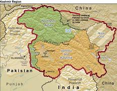
Thus, in China’s history lies its future and the extraordinary movement in recent Chinese land developments all lie along this path, the Silk Road, the alliances with Pakistan and more recently India also affect this region, particularly Kashmir [see map] and China sees the greater picture and rates it a main priority.
For example, China will spend 127 billion yuan (about 15 billion U.S. dollars) on railway construction in its western regions in five years, said Wang Linshu, general engineer of the Ministry of Railways, in 2001. The Ministry of Railways will help the western regions to have 25,000 km of railways by the year 2005, with 11,400 km in the southwest, he said. In the past ten years, the investment in railways in southwest China has accounted for more than 30 percent of the national total in railway infrastructure construction.
The projects, with an estimated investment of 220 billion yuan (approximately 26.6 billion US dollars), will increase the gross length of roads in southwest China to 380,000 kilometers. In southwest China, roads will also be built in 463 towns and 10,000 villages which at present lack transportation links, Cao said. MOC also planned to build international thoroughfares in the region to fit in with the country's huge scheme of developing the western region.
Now this is big money poured into myriad projects in a very short time and raises the question: “Why the urgency?”
 It bears all the hallmarks of a nation planning rapid expansion. The list goes on. Though China’s military strength is its land army, it has been forced by American activity in Tibet and surrounding regions and its encroachment in Afghanistan, to also build up other access and egress. Take port development, for example:
Oil shippingFrom the Washington Times: China is building up military forces and setting up bases along sea lanes from the Middle East to project its power overseas and protect its oil shipments, according to a previously undisclosed internal report prepared for Defense Secretary Donald H. Rumsfeld.
"[It] is building strategic relationships along the sea lanes from the Middle East to the South China Sea in ways that suggest defensive and offensive positioning to protect her energy interests, but also to serve broad security objectives," said the report sponsored by the director, Net Assessment, who heads Mr. Rumsfeld's office on future-oriented strategies.
China is adopting a "string of pearls" strategy of bases and diplomatic ties stretching from the Middle East to southern China that includes a new naval base under construction at the Pakistani port of Gwadar. Beijing already has set up electronic eavesdropping posts at Gwadar in the country's southwest corner, the part nearest the Persian Gulf and the post is monitoring ship traffic through the Strait of Hormuz and the Arabian Sea.
Other "pearls" in the sea-lane strategy include:
• Bangladesh: China is strengthening its ties to the government and building a container port facility at Chittagong. The Chinese are "seeking much more extensive naval and commercial access" in Bangladesh.
• Burma: Close ties to the military regime in Rangoon and turned a nation wary of China into a "satellite" of Beijing close to the Strait of Malacca, through which 80 percent of China's imported oil passes plus naval bases, electronic intelligence gathering facilities in the Bay of Bengal and near the Strait of Malacca. Beijing also supplied Burma with "billions of dollars in military assistance to support a de facto military alliance," the report said.
•Cambodia: Military agreement in November 2003 to provide training and equipment. Cambodia is helping Beijing build a railway line from southern China to the sea.
•South China Sea: Focus is "protecting or denying the transit of tankers through the South China Sea" and to be able to "project air and sea power" from the mainland and Hainan Island. A military airstrip on Woody Island was upgraded and its presence increased through oil drilling platforms and ocean survey ships.
•Thailand: Construction of a $20 billion canal across the Kra Isthmus that would allow ships to bypass the Strait of Malacca giving China port facilities, warehouses and other infrastructure in Thailand aimed at enhancing Chinese influence in the region.
Many Pentagon analysts believe China's military buildup is taking place faster than earlier estimates, and that it will use its power to project force and undermine U.S. and regional security. The U.S. military's Southern Command produced a similar classified report in the late 1990s that warned that Beijing was seeking to use commercial port facilities around the world to control strategic "chokepoints."
A Chinese company with close ties to Beijing's communist rulers holds long-term leases on port facilities at either end of the Panama Canal. The Pentagon report said that by militarily controlling oil shipping sea lanes, this could threaten ships, "thereby creating a climate of uncertainty about the safety of all ships on the high seas."
"China ... is looking not only to build a blue-water navy to control the sea lanes, but also to develop undersea mines and missile capabilities to deter the potential disruption of its energy supplies from potential threats, including the U.S. Navy, especially in the case of a conflict with Taiwan."
Weapons for sea-lane control include new warships equipped with long-range cruise missiles, submarines and undersea mines plus aircraft and long-range target acquisition systems, including optical satellites and maritime unmanned aerial vehicles.
The focus on the naval buildup is a departure from China's past focus on ground forces. It demonstrates a total strategic plan but for what purpose?
"The Iraq war, in particular, revived concerns over the impact of a disturbance in Middle Eastern supplies or a U.S. naval blockade," the report said, noting that Chinese military leaders want an ocean-going navy and "undersea retaliatory capability to protect the sea lanes."
China believes the U.S. military will disrupt its energy imports in any conflict over Taiwan, and sees the United States as an unpredictable country that violates others' sovereignty and wants to "encircle" her.
Beijing's leaders see access to oil and gas resources as vital to economic growth and fear that stalled economic growth could cause instability and ultimately the collapse of their nation of 1.3 billion people.
Energy demand, particularly for oil, will increase sharply in the next 20 years - from 75 million barrels per day last year to 120 million barrels in 2025 - with Asia consuming 80 percent of the added 45 million barrels. Eighty percent of China's oil currently passes through the Strait of Malacca, and the report states that she believes the sea area is "controlled by the U.S. Navy."
President Hu Jintao recently stated that China faces a "Malacca Dilemma" — the vulnerability of its oil supply lines from the Middle East and Africa to disruption. Oil-tanker traffic through the Strait, which is closest to Indonesia, is projected to grow from 10 million barrels a day in 2002 to 20 million barrels a day in 2020.
It’s clear that China is making strategic moves globally, as well as closer to home and the development of the west, along with the dams projects, point to it having every intention of using those routes.
The question is – for what purpose? Recent photos taken along the route of what seem like military manouevres may offer one answer. Part 4 will follow.
 Hill of Megiddo underlined